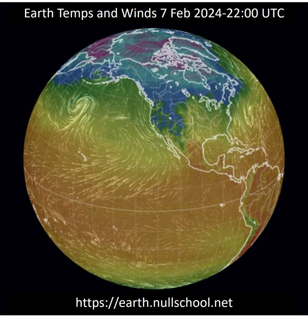
The northern great plains of the U.S. experienced an exceptionally mild 2023-2024 winter, about 10 degrees Fahrenheit above normal, due to the onset of a strong El Nino event, now called a Super El Nino by some. As is shown below, this categorization as super is overstated. Hyperbole by the press is a bad habit they just can’t seem to break.
National Geographic defines an El Nino, along with its sister event, La Nina as, “…a climate pattern that describes the unusual warming of surface waters in the eastern equatorial Pacific Ocean. El Nino is the “warm phase” of a larger phenomenon called the El Nino-Southern Oscillation (ENSO). La Nina, the “cool phase” of ENSO, is a pattern that describes the unusual cooling of the region’s surface waters. El Nino and La Nina (EN) are considered the ocean part of ENSO, while the Southern Oscillation (SO) is its atmospheric changes.”
El Nino events last from 9-12 months on average with a rare occurrence lasting up to 18 months. La Nina events can endure for longer periods than El Ninos with some lasting up to 24 months. Both weather events reoccur every 2-7 years for reasons unknown but may be, and this is stretch on my part, related to polar and core wobbles. Earth’s axis experiences two discrete periodic oscillations; the 14 month Chandler Wobble and a 12 month wobble. These two wobbles cause the poles to trace a spiral path over about 6.5 years. Earth’s inner core mysteriously wobbles with a periodicity of approximately 8.5 years. The combination of these wobbles may help explain the peridicity of ENSO weather events.
The National Oceanic and Atmospheric Administration states: “El Nino usually causes increased rainfall and sometimes destructive flooding. La Nina, however, usually causes drier weather in the South, but the Northwest tends to be colder and wetter than average. Even though El Nino occurs in the Pacific Ocean, it often reduces the number of hurricanes that form in the Atlantic Ocean. Conversely, La Nina events tend to be related to an increase in the number of Atlantic hurricanes.”
Hurricanes in the Atlantic Basin occur less often, supposedly, during El Nino than La Nina. This is because there is less vertical wind shear in the troposphere during a La Nina than an El Nino. Wind shear tears hurricanes apart while the lack of wind shear allows hurricanes to form and intensify. Wind shear in the troposphere develops due to pressure gradients which in turn are caused by temperature contrasts between the ocean surface and high-altitude tropospheric air. During El Nino warm ocean surface waters create a greater contrast with the high-altitude cool troposphere air than the cooler La Nina ocean surface waters do. Wind shear lessens when the temperature contrast decreases between the ocean surface and higher altitudes. When ocean temperatures are higher, wind shear is greater resulting in fewer hurricanes. With lower ocean temperatures, wind shear is less resulting in more hurricanes.
This is the theory, whereas actual hurricanes making landfall appear to increase in numbers after weak to moderate El Ninos rather than strong ones. There doesn’t appear to be any correlation between strong El Ninos and increases in hurricanes making landfall during the subsequent La Nina events.
This year’s El Nino was driven by a larger than normal spike in Pacific Ocean temperatures that were about 0.5-degree Fahrenheit above 2022 temperatures. This is considered an exceptionally large increase. This has led to warmer, dryer winters in the upper mid-western states of the U.S. along with greater precipitation in the western U.S.
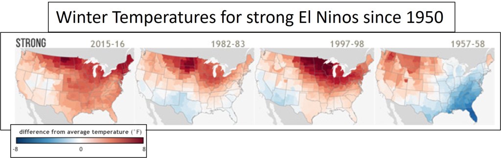
The graph below, from NOAA Climate.gov, shows the change in average winter temperatures during strong El Ninos since 1950. In northeastern North Dakota during the 2023-2024 winter, from the months December to February, temperatures are about 10 degrees warmer on average than the previous year’s winter temperatures. This increase is similar to what was experienced in the 1997-1998 El Nino.
The graph below, again from NOAA Climate.gov, shows winter precipitation during strong El Ninos since 1950. In Long Beach, California the 1997-1998 winter brought 17.77 inches of rain whereas the winter of 2023-2024 has already brought 13.88 inches of rain with 19 days left in the month of February to add to that total. This year’s winter precipitation in Long Beach should be similar to what occurred in the 1997-1998 winter season.
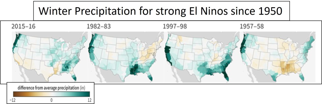
The winter that is occurring in northeastern North Dakota is like what happened temperature-wise 26 years ago during the 1997-1998 winter. Similarly, in Long Beach California the El Nino induced precipitation is likely to be about the same as the totals for this same El Nino event.
In conclusion the strong El Nino of 2022-2023 is a carbon copy of the strong El Nino that occurred 26 years ago during the winter of 1997-1998. The end of 1997-1998 El Nino was followed by seven hurricanes making landfall during the 1999 season suggesting the 2024 season should see about the same number of hurricanes making landfall.
References and Readings:
- Impacts of El Nino and La Nina on the Hurriane Season. By Gerry Bell. Climate.gov. 2014
- El Nino and La Nina. By Unknown. NOAA. 2015
- U.S. Winter Temperatures for Every El Nino Since 1950. By Rebecca Lindsey. Climate.gov. 2018
- U.S. Winter Precipitation during every Every El Nino Since 1950. By Rebecca Lindsey. Climate.gov. 2018
- ‘Super El Niño’ Is Here, but La Niña Looks Likely. What’s in Store for the Coming Months. By Mary Gilbert. CNN. 2024
- ‘Super’ El Niño Is Here. What Does this Mean for Our Weather? And What Happens Next? By Doyle Rice. USA Today. 2024
- El Nino. By Unknown. National Geographic. Date Unknown
